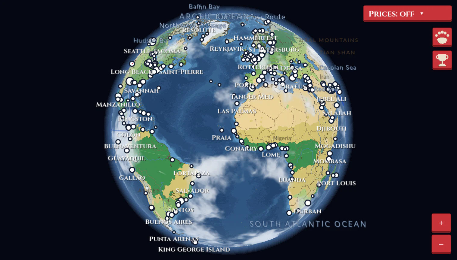
The whole Earth as a globe, seen from space (an orthographic view, north kept up), like Google Earth. Drag to turn it (the map follows the mouse; let go while moving and it keeps spinning, slowing to a stop), and zoom with the mouse wheel (easing in and out, about the point under the mouse), or on a trackpad by pinching (about the fingers) or swiping two fingers up and down like the wheel, or with the + and - keys, or the World map's + and − buttons at its bottom right, from the whole globe (90% of the view's height across) down to a close view of a harbor. The view can turn right over the poles (Antarctica's ice and the deep Arctic Ocean reach them). Around the globe is dark space with a soft blue glow of air at its edge; the globe darkens a little and fades into haze towards its edge.
How it's drawn: the map data stays in Web Mercator map coordinates. Ships' headings and the docks turn with the globe's north where they are. The biomes are cut to the land by a land mask drawn off screen. Sizes set in projected degrees (canal channels, locks, the land drawings' spacing) shrink towards the poles as the land does; ships and docks keep their size in the world. Piers show once a port's docks are 8 px out to the mouth.
Keeping the map fast (zoomed in to the marinas, and dragging): each port's marina is drawn once into its own canvas item at the zoom it's drawn at and then only moved and turned with the view (drawn again only when the zoom changes, the port changes size or becomes a hub, or its HQ building grows). Label text sizes are measured once, and labels, ports, land drawings and lanes' points are kept on the unit sphere (they never move) and looked up by cell of the globe near the view, so off-screen ones cost nothing (a long segment, open ocean between two points far apart, is drawn in pieces along the path the ships sail, straight in the map's projection, which bends with the globe zoomed out, so a ship's dot sits on its line: before, the straight screen line between the points left dots up to 30 px off at the widest zooms); the route lines' harbour curves are worked out once a zoom (and again after the view moves a degree) and kept on the globe; the land mask under the biomes is drawn again only when the view changes; birds' shapes are a bird a unit across, scaled as they're drawn, and their colors read once; what birds are where is kept for a game minute; sea animals' wander spots and the calendar year are worked out once. None of it changes how anything plays or looks.
Map art: blue sea, sandy land with a darker coastline, thin country borders, lakes (drawn with a shoreline, each in a simplified version of its real color: clear blue for most fresh water, deeper blue for very deep clear lakes like Baikal, Tanganyika, Malawi, Titicaca and the upper Great Lakes, green for shallow plant-rich ones like Victoria, Erie and Winnipeg, muddy for Chad and Tonle Sap, turquoise for glacial and salt lakes like the Dead Sea, jade for Turkana, pink for red-algae ones like the Syvash, and salt-white for dry salt pans like Lake Eyre and inland Australia's; islands in them are land; plain gray on the route map), thin blue rivers (the biggest show zoomed out, smaller ones appear as you zoom in; visual only, ships don't sail them), and country names that appear as you zoom in (placeholder colors, all in the theme).
Taken out: Los Angeles, Indiana Harbor, Burns Harbor and Algeciras. In older saves, anything at or bound for one (ships, routes, hubs, home ports) goes to its neighbour instead: Long Beach, Gary, Gary and Tanger Med (a route stopping twice in a row at one port stops there once; two hubs at one port keep the HQ). Chicago sits on the downtown lakefront and Gary a little east of its old spot, turned a little left, so the two stay clear of each other even as full-sized ports (not both as hubs); Philadelphia a little south-west, facing down the Delaware; Hong Kong a little south-west and Shenzhen a little north-east; Tokyo north-east and Yokohama south-west of where they were, Yokohama facing south down Tokyo Bay; Kobe north-west and Osaka south, apart across Osaka Bay; Tanjung Pelepas a little north-west and Singapore a little east; Ningbo-Zhoushan facing east by south-east.
The world's biggest container ports (the top 100, plus the next several so that 100 are new beyond the original Mediterranean set). Ranks 1–25 follow the published 2023 figures; the rest follow recent Lloyd's List rankings as best known (the full list is paywalled), so a few borderline ports may differ from the official list.
The 18 biggest Mediterranean container ports, plus Rome (Civitavecchia) and Tunis (Radès).
Also: Boston, Miami, Monterey, Anchorage, Seattle-Tacoma, Cabo San Lucas.
Added for coverage: New Orleans, Havana, Port-au-Prince, San Juan, Bridgetown, Cancun, Puerto Quetzal (Guatemala), Puntarenas (Costa Rica), Puerto Ayora (Galapagos); Honolulu, Nawiliwili (Kauai), Apia (Samoa), Pago Pago (American Samoa), Nuku'alofa (Tonga), Suva (Fiji), Papeete (French Polynesia), Auckland, Wellington, Apra Harbor (Guam), Port Moresby, Cebu, Muara (Brunei); Toamasina (Madagascar), Praia (Cabo Verde); Dublin, Douglas (Isle of Man), Reykjavik, Nuuk, Juneau, Dutch Harbor (Aleutians); Gothenburg, Oslo, Copenhagen, Aarhus, Bergen, Tallinn, Riga, Klaipeda; Durres; Constanta, Odesa, Novorossiysk.
Added to reach 200: Saint-Pierre, Portland (Maine), Nain (Labrador), Hamilton (Bermuda), Ponta Delgada and Faja Grande (Azores), Funchal (Madeira), Porto, Nantes-Saint-Nazaire; Portland (Oregon), Hilo and Kawaihae (Big Island of Hawaii), Malakal (Palau), Vladivostok, Korsakov (Sakhalin), Magadan, Petropavlovsk-Kamchatsky; Rio de Janeiro, Salvador, Fortaleza, Buenaventura, Antofagasta, Punta Arenas; Banjul, Freetown, Luanda, Maputo.
Added with Suez and the Great Lakes: Ain Sokhna and Port Tewfik (Egypt, south end of the Suez Canal), Eilat (Israel), Noumea (New Caledonia), Flying Fish Cove (Christmas Island), Midway Atoll; the 15 biggest Great Lakes ports (Duluth-Superior, Two Harbors, Thunder Bay, Presque Isle on Superior; Chicago, Indiana Harbor, Burns Harbor, Gary, Milwaukee on Michigan; Calcite on Huron; Detroit, Toledo, Cleveland on Erie; Toronto, Hamilton on Ontario); and six Antarctic stations.
Added to reach 300 (ranks 228-300, after the rest): a port for every coastal country of over a million people that had none: Helsinki (Finland), Ust-Luga (Russia's Baltic), Rijeka (Croatia), Varna (Bulgaria), Poti (Georgia), Latakia (Syria), Beirut (Lebanon), Algiers (Algeria), Misrata (Libya), Aqaba (Jordan), Aden (Yemen), Khalifa Bin Salman (Bahrain), Shuwaikh (Kuwait), Umm Qasr (Iraq), Port Sudan (Sudan), Massawa (Eritrea), Mogadishu (Somalia), Dar es Salaam (Tanzania), Walvis Bay (Namibia), Nouakchott (Mauritania), Dakar (Senegal), Bissau (Guinea-Bissau), Conakry (Guinea), Monrovia (Liberia), Cotonou (Benin), Douala (Cameroon), Malabo (Equatorial Guinea), Owendo (Gabon), Pointe-Noire (Republic of the Congo), Banana (DR Congo, at the Congo's mouth), Yangon (Thilawa; Myanmar), Sihanoukville (Cambodia), Dili (Timor-Leste), Nampo (North Korea), Puerto Cortes (Honduras), Acajutla (El Salvador), Corinto (Nicaragua), Puerto Cabello (Venezuela), Caucedo (Dominican Republic), Port of Spain (Trinidad and Tobago), Montevideo (Uruguay); and more in the thinner regions: Kolkata (Haldia), Visakhapatnam, Kochi, Paradip, Mongla; Belawan, Makassar, Balikpapan, Davao, Da Nang; Cape Town, Beira, Nacala, Onne, Lobito; Vostochny, Vanino; Suape, Vila do Conde, Vitoria, Itajai, Rio Grande, Bahia Blanca, Valparaiso; Baltimore, Philadelphia, Jacksonville, Halifax, Mobile; Fremantle, Adelaide, Darwin. Bosnia (Neum) and Gaza have coast but no working commercial port. Then Buffalo (New York, on Lake Erie at the Welland Canal's south end; rank 301): its clothing and coffee 2% dearer, so a Scooter makes about $1,300-1,600 to Toronto or Hamilton and $1,000-2,700 to Toledo or Detroit.
Added later (ranks 318-326, Northern Europe & Atlantic market): Liverpool, Immingham and Teesport (England's west and east coasts), Milford Haven (Wales), Grangemouth and Greenock for Glasgow (Scotland), Las Palmas (Canary Islands), Bilbao (northern Spain) and Tórshavn (Faroe Islands).
The map opens centered on the company's home port (45 degrees of longitude across); the route screen opens centered on the ship.
The land is drawn in simplified biomes, each one flat color with sharp straight edges between them and no shading: ice, tundra (and cold high plateaus like Tibet), boreal forest, temperate forest, tropical rainforest, grassland and steppe, savanna and dry scrub, and desert. Each is worked out from Natural Earth II's land cover color and the latitude, then smoothed into simple patches. The coastline stays as sharp as the land data. The sea darkens with depth in 12 bands, from light blue over the continental shelves (0-200 m) to deep navy in the trenches (Natural Earth bathymetry at 200, 1,000, 2,000... 10,000 m). A faint line marks the equator. The route screen's gray map keeps flat gray land and sea.
Dredged passages: the Strait of Messina, the Bosporus, the Dardanelles and the St. No ship anchors in the Strait of Messina. Canals and their cuts through the quays are a little wider.
Ports moved on 2026-10-10: Tanger Med south and east into open water (35.72 N, 5.30 W, out north-east) so the strait is open; Gibraltar added in line above it (36.21 N, 5.30 W, out south-west; mediterranean market), a lane's width between their jetties; Eilat and Aqaba are one port, Eilat & Aqaba; Koper turned to face west about its old entrance (its centre moved east to 45.711 N 13.776 E); Port Tewfik faces south down the Gulf of Suez with its entrance on the water (29.92 N). A town's blocks never stand on a neighbouring port's quay, basin or harbour.
The land is covered with drawings at their size in the world, growing and shrinking with the map like the land: some 130,000 of them. Mountains along the real mountain ranges, 0.42 degrees apart so their peaks overlap into ridges, in three shapes, each with a lit face and a shaded one, ridges and scree (74-92 km across), snow-capped in cold places and all along the great snowy ranges (the Himalayas, Andes, Alps, Rockies, Karakoram, Caucasus, Southern Alps...). On the sea beyond 60 degrees north and south, waves mark the rough polar waters (the Southern Ocean wears ships twice as fast; see Rough seas). And a pizza on Albuquerque, a close-up secret (7 km). A drawing shows once it's 5 px across, and all of them from 16 px (in between only some, by a random tier, so the land thins out zoomed out rather than turning to noise: forests read as texture from mid zoom and as stands of trees close in), standing on its spot, lower ones in front, imported at 4x so they stay sharp close in. Each is drawn only while it's at least half its size from the nearest shore, so no land drawing reaches into the water. Not in locked regions; the gray route map has none. The animals live on the map as the wildlife (see Wildlife). The trees change with the seasons: by the calendar, for each drawing's hemisphere (the south's six months on), spring (March to May) brings the cherry trees' blossom, autumn (September to November) turns the round trees, oaks, birches and cherries orange, yellow and red, and winter (December to February) leaves them bare and grey, each drawing changing over at its own moment in the season's first 24 days; beyond the snow line the land lies white and the trees carry snow (the conifers, and the bare trees' snow versions). Each kind's seasonal versions are their own art, loaded after the kinds.
Ocean, sea and strait names have a thin dark edge so they read over shallow and deep water alike. Each shows from Natural Earth's own zoom, sits well inside its area (a river on the middle of its longest named stretch), and never overlaps another label: ports first, then countries, then oceans, seas, rivers, ranges, deserts, straits and lakes (so a river shows across a mountain range). Rivers are named in full ("Mississippi River"), unless the name already says river ("Rio Grande", "Syr Darya"). If its best spot is taken, a label (except a river's) tries a few spots just around it. Ten ocean trenches are labeled too: the Mariana, Tonga, Kermadec, Philippine, Kuril-Kamchatka, Japan, Aleutian, Peru-Chile, Puerto Rico and Java trenches, in pale teal slanted letters with the sea names' dark edge, placed after the straits. The route screen's gray map has none.
Ports are white circles with names; when names would overlap, the HQ's or a hub's name wins, then the bigger port's, and the other shows on zoom. The HQ and hubs are drawn on top of other ports (circle and company-color ring), so a big neighbouring port never covers them.
Every port has a size from 1 to 100, in four bands: Small 1–25, Medium 26–50, Large 51–75, Giant 76–100. Each save keeps its own sizes.
Starting sizes: within each market region (East Asia, the Mediterranean, the Great Lakes, Antarctica...), ports are banded by real container volume (the top ~15% Giant, the next ~25% Large, the next ~30% Medium, the rest Small; at least one of each per region: 34 Giant, 58 Large, 69 Medium, 66 Small) and spread by rank within the band (Shanghai 100, Hong Kong 63, Rome 29, Taipei 11).
Growth: the cargo value your ships unload (sales) and load (purchases) at a port grows it by value ÷ ($720,000 × its size) points, so bigger ports need more. Tuned so a mid-game company's busiest port (about $60M an hour through a size-50 port) climbs a band in about 15 hours. Growth is banked (up to 5 points) and applied at no more than 5 points an hour (a band in 5 hours), so late-game fleets grow their busy ports at that cap.
Shrinking: from company level 46, every port above 51 loses 0.83 points an hour (a band in about 30 hours), less whatever it grows, and never goes below 51 (a Large or Giant port stays at least Large). Small and Medium ports never shrink, and nothing shrinks before level 46.
Effects (Large ports play exactly as before sizes; the effect scales smoothly outside 51–75): your trades move prices up to 2x as much at size 1 and half as much at 100, and their effect takes that much longer or shorter to fade; fuel and repairs cost up to 20% more at size 1 and 20% less at 100 (on top of hub discounts).
Ship limits: tier-5 ships (Dominator, Capesize, Post-Panamax Bulker, Ocean Shearer, Supertanker, Giant Car Carrier) dock only at Large and Giant ports; tier-4 ships (Trans Atlantic, Panamax Bulker, Kamsarmax, Livestock Carrier, Aframax, Car Carrier) at any port but Small; the rest and recovery boats anywhere. Both also dock at any port with an HQ or hub (any company's), whose piers are all long enough for the biggest ships, so a hub at a small port can take a Dominator (and grows fast on its traffic). The route screen greys out ports that are too small, lists each stop with its size ("1. Taipei (Medium 26)"), says what the ship needs ("Docks only at Medium ports or bigger, or at an HQ or hub") and why a click was refused ("Muara (Small 9) is too small for a Panamax Bulker, which needs a Medium port or an HQ or hub"). New ships launch at any HQ or hub (but not a tier-4 or 5 ship at a Great Lakes one). A ship whose next port is too small is held ("assign a new route"), though with the size floor this can't happen in normal play.
On the map a port's dot grows smoothly with its size: 3 px radius at 1, 6 at 63 (as before), 9 at 100; docked ships ring just outside it and hub rings hug it.
The port popup's title shows it ("Taipei · Medium 26"), then "Size 26.1 of 100, growing (+5.0 an hour) · next: Large at 51" with a bar through the band, its effects ("Fuel & repairs +10% · your trades move prices 1.50x") and "Too small for ships needing Large ports" (or "Every ship can dock here").
The activity log says when a port grows or shrinks into a new band ("Taipei grew to Medium"); a shrink is only announced a point below the band, so a port on a band's edge doesn't flip back and forth.
Lanes use the Suez and Panama canals and the main straits and river approaches (Gibraltar, Messina, Bonifacio, the Dardanelles, Singapore, the Great Belt, the Elbe to Hamburg, the Scheldt to Antwerp, the Golden Gate, Puget Sound, the Bosphorus to the Black Sea, the Mississippi to New Orleans, Icy Strait to Juneau, the Oslofjord, the Columbia River to Portland, the Strait of Magellan, and others). All distances are real nautical miles along those lanes. Routes cross the Pacific without a seam. Every port's lanes come in to it along a few shared approach channels, like a real port's traffic separation scheme: its lanes' ends are gathered by the bearing they come in from, those within 30 degrees of each other together, and each group's last 80 nm are one and the same way (the lane nearest the group's middle), the rest leaving their own way 105 nm out to join the channel's outer end straight across, with the two corners rounded, where that join is clear of the coast (else the lane keeps its own way in). Lanes under 260 nm, and lane ends at a port on a canal or through one, keep their own ways. 318 ports have channels, 3.6 each on average; lanes got 5.6 nm longer on average where they changed (0.04% in all; a few giant single-segment lanes to the Antarctic stations measure over 100 nm longer, as their great-circle distances were never the length of the straight Mercator line ships sail).
Nhava Sheva and Kochi a little west; Mundra mirrored to face west by south-west into the Gulf of Kutch; Yangon (Thilawa) down to the Gulf of Martaban, out south; Sihanoukville out south-west; Muara out north; Laem Chabang a tad east; Surabaya south and east along the Madura strait; Jakarta north and west; Xiamen south and east; Manila out at the mouth of Manila Bay; Oakland down the bay clear of the Golden Gate Bridge, out north-north-west; and Guangzhou, Hong Kong and Shenzhen side by side facing south by south-east, Hong Kong in the middle and furthest out, like a podium (Guangzhou out in the estuary south-east of Macau, so its lanes clear Macau and Lantau).
 Maritime Empire